REMOTELY PILOTED AIRCRAFT SYSTEMS (RPAS)

Advanced RPAS services.
Plan. Deliver. Manage.

Engage Drone Alliance for a specialist assignment or a coordinated project campaign. We assist with flight plans, work method statements, field operations and delivery management.

Scope your assignment

OPERATIONAL ASSURANCE

Licensed and insured for Australian operations.

Drone Alliance holds Civil Aviation Safety Authority (CASA) certification and maintains the licences and insurance required for its Australian Remotely Piloted Aircraft Systems (RPAS) operations.

Chief Remote Pilot (CRP)
Paul Bromilow

Operating responsibilities, site requirements and the scope of each assignment are agreed before mobilisation.

Professional aviation governance.

Drone Alliance combines disciplined operating procedures with Aviation Compliance and Risk Management (AVCRM) software to support safe, efficient and accountable operations. Our approach brings together mission planning, risk assessment and operational records to support compliance with applicable CASA requirements and each client’s aviation governance requirements.

Explore AVCRM

TYPICAL APPLICATIONS AND SCOPED OUTPUTS

Start with the decision
your team needs to make.

Mining & bulk materials

Understand terrain. Track material.

Applications
Terrain mapping, stockpile measurement and site-change capture.
Deliverables
Agreed surface models, volume calculations and repeat-survey comparisons, with coordinate reference, control and accuracy checks.
Client benefit
Support material reconciliation, site planning and comparisons between capture dates.
Scope a mine-site survey

Infrastructure & built assets

See the asset. Prioritise the finding.

Applications
Bridges, communication towers and industrial structures.
Deliverables
Textured three-dimensional (3D) models, located findings, dimensions, criticality and evidence references.
Client benefit
Help maintenance and engineering teams review condition and prioritise further investigation.
Scope an asset inspection

Energy & process facilities

Inspect complex assets. Direct the next action.

Applications
Confined-space visual inspection, thermal investigation and gas detection.
Deliverables
Inspection records, located indications, capture conditions and recommended follow-up. Gas quantities only where the method and data support them.
Client benefit
Support maintenance planning, targeted investigation and operational decisions.
Scope a facility inspection

BESPOKE ASSIGNMENTS & CAMPAIGN SUPPORT

Support before, during
and after the flight.

Flight planning

A task-specific mission plan covering capture requirements, aircraft and payload selection, crew roles, site constraints and contingencies.

Work method statements

A documented work sequence with task risks, controls, responsibilities and site interfaces, prepared for review within the agreed operating arrangements.

Campaign management

A coordinated campaign programme covering mobilisation, site access, capture schedules, progress reporting, data checks and deliverable handover.

Select planning support, field delivery or full campaign management. Agree operational responsibilities, site permissions, data specifications and acceptance criteria before mobilisation.

Agreed scope. Checked outputs. Documented handover.

Before mobilisation, agree the asset coverage, intended use, required accuracy, inspection criteria, deliverable formats and acceptance requirements. At handover, provide the agreed outputs with their quality checks, coverage gaps, stated limitations and revision identification.

  1. DefineAgree the intended use, coverage and acceptance criteria.
  2. CaptureApply the agreed method and record site conditions.
  3. ReviewCheck the data, interpretation and stated limitations.
  4. DeliverHand over agreed outputs, findings and revision records.
Agree the deliverable before capture

Define intended use, asset coverage, coordinate reference and units, required accuracy, validation checks, file formats and acceptance criteria.

Spatial outputs
Point cloud, model, orthomosaic, surface or volume, as scoped.
Inspection outputs
Located findings, supporting evidence and reviewed recommendations.
Handover
Agreed files, quality checks, inaccessible areas, measurement limitations and revision identification.
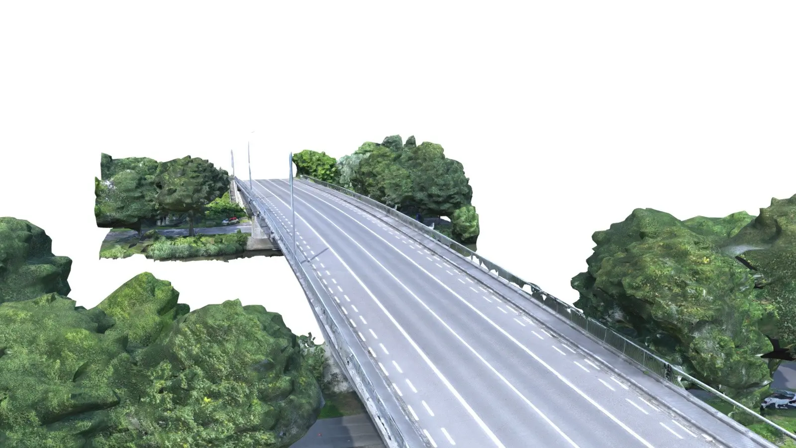
Textured photogrammetric reconstruction of Durmenbrug, showing the bridge deck, abutments and reconstructed surroundings against a white background
Textured bridge reconstruction · Reference example
Explore the original 3D model

PHOTOGRAMMETRY AND THREE-DIMENSIONAL (3D) MODELLING

Make the whole asset
available to the whole team.

Reconstruct bridges, towers and industrial structures as measurable models. Combine image-based reconstruction with complementary laser-scan data where the scope requires it.

Textured 3D models Orthomosaics Location-linked findings
Applications and deliverables

Capture geometry, image quality and control are matched to the task. Deliverables may include models, visual inspection records, orthomosaics and measurements with agreed accuracy checks and documented limitations.

Discuss your 3D capture project

Durmenbrug, Belgium. Photogrammetry reference by erkki.bartczak / KU Leuven; not a Drone Alliance project.

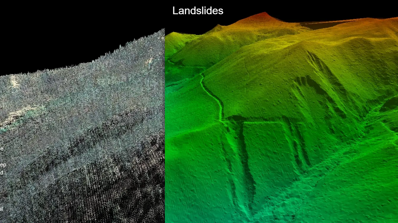
Point cloud alongside a bare-earth elevation model revealing terrain and landslide features beneath vegetation 02 / 05

Reference example: point cloud and bare-earth terrain model, United States Geological Survey.

Light Detection and Ranging (LiDAR)

Geospatial survey, terrain and model-ready geometry.

Drone and handheld capture for terrain, structures and constrained environments. Point clouds support topographic analysis and Building Information Modelling (BIM) workflows.

What you receive

Registered and classified point clouds, bare-earth surfaces and agreed spatial outputs. Scan-to-model delivery requires model development and verification against the specified accuracy and level of detail; a point cloud alone is not a completed building information model.

Discuss your application
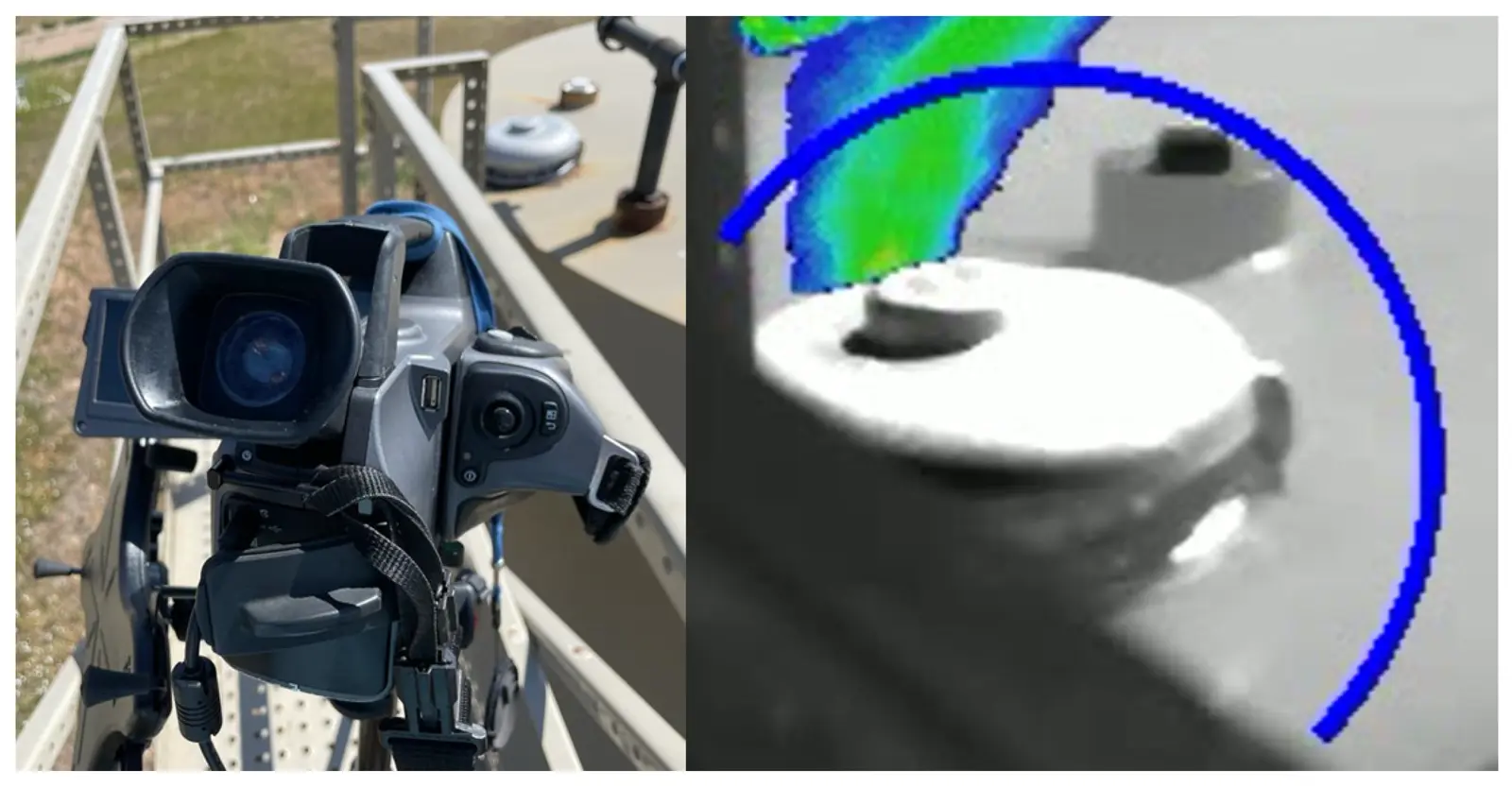
Research example pairing a ground-based gas camera with a highlighted methane plume from a controlled release 03 / 05

Research example: ground-based optical gas imaging of a controlled release. Colour highlights the detected plume.

Gas Detection & Quantification

Locate emissions. Build evidence for action.

Match the sensor and measurement approach to the gas, asset and investigation.

What you receive

Located indications, capture conditions and quantified emissions where the method and data support them.

Discuss your application
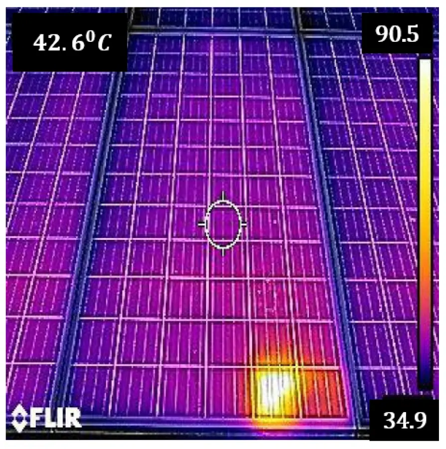
Published thermal image of a solar-cell hotspot with its original temperature scale and measurement marker retained 04 / 05

Published example: solar-cell hotspot. Original temperature scale retained; no diagnosis is inferred from this image alone.

Thermography

Identify the thermal anomaly. Explain its significance.

Record hotspots and other thermal anomalies with asset location, visible evidence and inspection conditions. Interpret findings before recommending follow-up.

What you receive

Located anomalies, contextual interpretation and prioritised follow-up recommendations.

Discuss your application
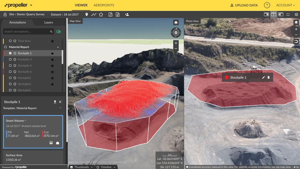
Quarry stockpile survey showing a three-dimensional volume model, measured quantities and the aerial stockpile image 05 / 05

Surveying

Spatial data with a defined purpose.

Plan around coordinate systems, control, accuracy and the professional use of the output.

What you receive

Surface, level, mapping and volume outputs with agreed control and independent checks.

Discuss your application

These are attributed research and application examples. They illustrate the type of information a method can produce and are not Drone Alliance project records.